10 Reasons Why Using Land Ownership Maps Adds Value To Your Research
*This post may have affiliate links, which means I may receive commissions if you choose to purchase through links I provide (at no extra cost to you). All opinions remain my own.
Maps are a wonderful resource for genealogists, and cadastral maps are no exception.
These land ownership maps are an underused resource that can help you put your ancestors’ daily lives into context.
They can also point you to other sources for your family history research, where you can uncover even more.
In this article, I’ll go over what cadastral maps are, how they benefit your genealogy research, and resources for finding maps of the regions where your family lived.
What are cadastral maps?
Cadastral maps show property ownership. These represent a specific time and place, which could be a town, a county, or another larger jurisdiction.
They record not only urban areas but also rural ones. This makes them a good resource for ancestors that weren't city dwellers and where there could be fewer records available about them.
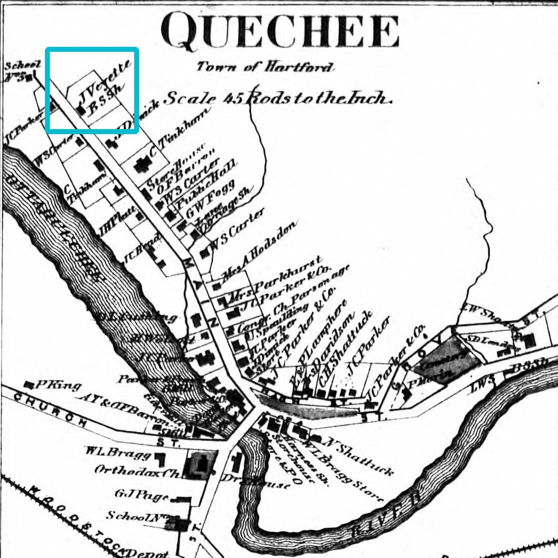
Source: Ancestry.com
This plan of Quechee, Vermont shows the home of my 4x great grandfather, Jean-Placide Veillette (AKA John Veyette).
Historic property maps show landowner names and property lines, as well as local services such as churches and the telegraph office. They may also include business directories. They can also show transportation options for the town, such as railroad lines and rivers.
Related posts:
Why You Need to Use Libraries and Archives in Your Genealogy
How to Strengthen Your Cemetery Research Skills to Find More Clues
Why Local History Books Are More Important Than You Think For Genealogy
Reasons to use historic land ownership maps in your genealogy research
1) See the actual location your ancestor lived. Okay, this point is a given, but seeing their name can be not only exciting but also put their location into perspective (see #4).
Although city maps may not have the owner’s name because of space limits, streets and house numbers are generally labeled. You can use information from the censuses and other sources to pinpoint the house location.
2) Discover the name of the street they lived on. For rural areas, street names usually weren’t recorded on the census and there may not be a city directory created for the area. Because of this, historic property maps are a good way to identify a more precise place where your ancestor lived. Even though street names weren’t always included, you can compare the cadastral map to a modern one to figure out the general location.
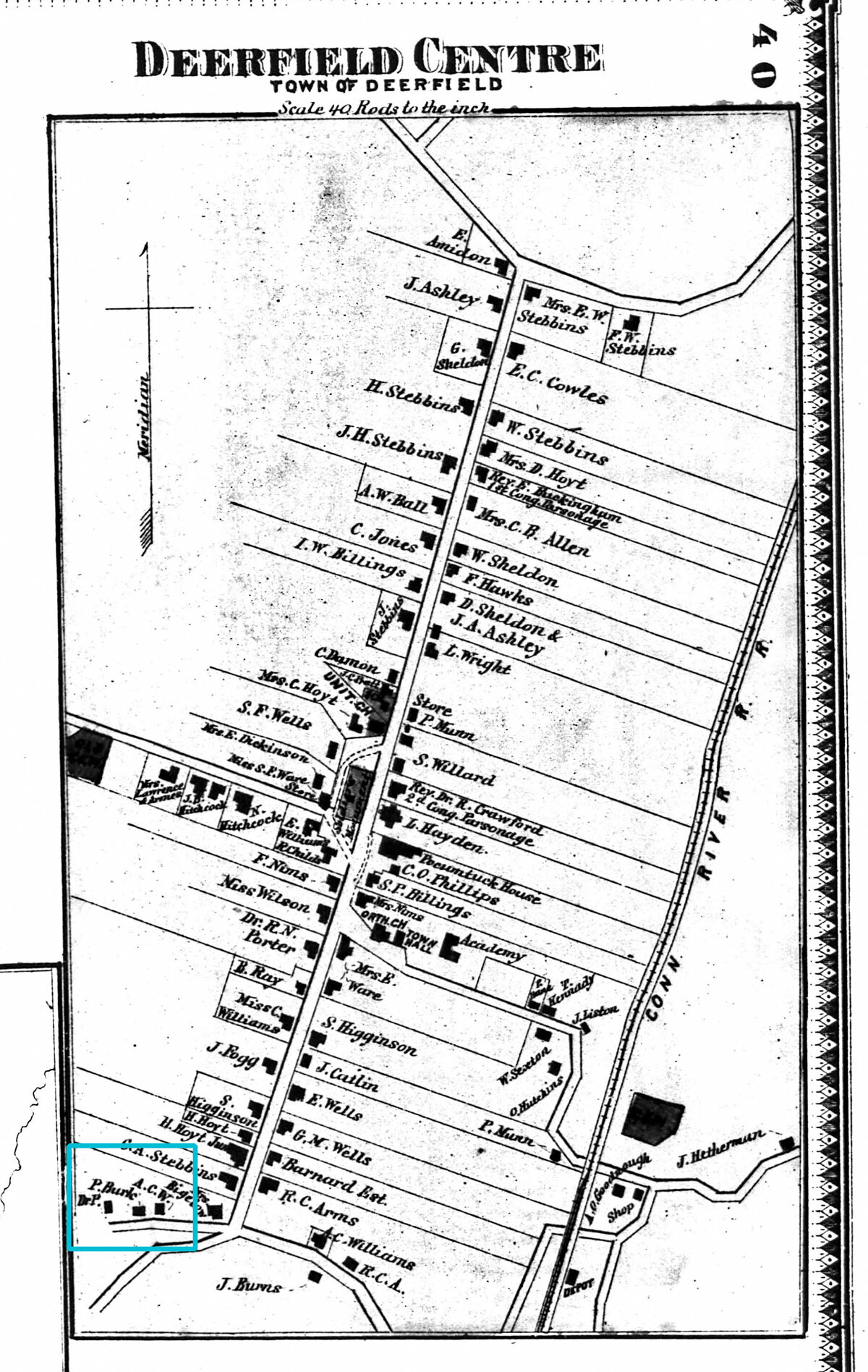
My 3x great grandfather’s house. Source: Ancestry.com
3) Find other households with the same surname. You may uncover new brothers, uncles, or cousins. Because these drawings show you where people were living between censuses, they can lead you to family members you didn't know about.
4) Locate cultural and civic features. What churches and schools did they live nearby? What businesses were in town that they may have used? Were they close to the post office or railroad station?
5) Reveal topographical features with your family’s surname. Are there lakes, hills, or other local topographic landmarks with your family’s last name? If so, could the name have come from your family?
Where my dad grew up, there was a pond called Cummings Pond, named after the family his great-aunt married into.
6) Locate other records. If you found your family on a map of property owners, then you can then look for deeds. You might also track down tax records for that property. And as a property owner, they likely left a will, leading you to probate records.
7) Identify their neighbors, a component of the FAN Club research method. Their neighbors could be relatives. It wasn’t uncommon for married couples to live nearby their parents or other family. Or, they could have migrated or immigrated from the same hometown.
Researching the neighbors may be what you need to break through a brick wall.
8) Put distances between where families lived into perspective. My 4x great-grandfather lived in Whately, Massachusetts. His son lived in Deerfield, about 8 miles away. That’s not far by today’s standards but would have taken a long time to trek back in the day.
But when I found them both on an 1871 map, I saw their houses were quite close to each other, making it much easier to visit one another.
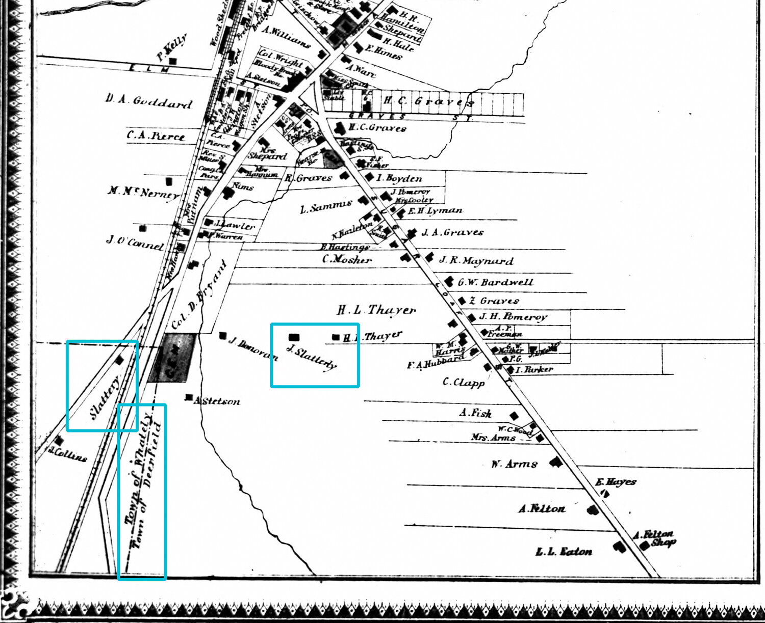
Source: Ancestry.com
9) See how long your family lived somewhere and where they moved. Using landowner maps from different years can help you trace where they moved within the same place, and about when they moved. It can also give you a clue they might have moved away, sold the land, or could have died if they disappear from the atlases.
10) Track how the area has changed and grown by comparing it to later drawings. You can see if their address still exists, if their house is still there, if the street has changed names, or other interesting differences.
Related posts:
Solve Your Genealogy Brick Wall: Review and Analyze Your Research
Solve Your Genealogy Brick Wall: How To Research A Last Name In An Area
Solve Your Genealogy Brick Wall: 10 Ways To Widen Your Research Net
What information can you find on landowner maps?
Besides, of course, naming local property owners, these maps can also show things like:
Rivers and other bodies of water
Railroads
Roads and their names
Schools
Churches
Cemeteries
Hills and mountains
Stores
Town and county borders
Neighborhood and village names
Mills and factories
Reservoirs
Forests
On more urban maps, you may also find the shapes of buildings
Being able to picture things like schools and stores is important for social history. You can see how close your ancestors were to the general mercantile shop, where they might be buried, and how far they had to go to get to school.
You can develop a sense of the community by seeing the whole picture, and the exact location your family lived.
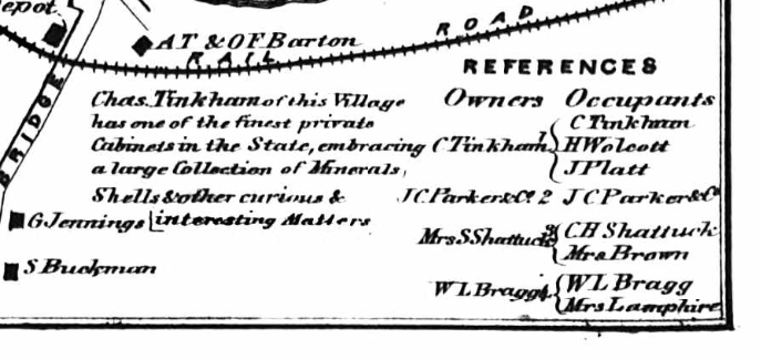
Be sure to also look for a map legend or reference box, which may give you more details about the locality.
This map of White River Junction, Vermont, says that “Chas. Tinkham of this Village has one of the finest private Cabinets in the State, embracing a large Collection of Minerals, Shells & other curious & interesting Matters.” How fun is that? That’s the kind of detail that you may not find anywhere else.
Source: Ancestry.com
The same reference box lists renters.
You may also find names of businesses and the type of materials used to construct a building.
Related posts:
11 Smart Tips For Using Archives In Your Genealogy Research
How To Avoid A Brick Wall And Research Your Ancestors With Common Names
10 Clues In Historical Land Records For Your Genealogy Research

What if I don’t see my ancestors on the maps?
If you can’t find your ancestors’ names on a landowner map, they not have yet moved to the area, or they did not own land.
It’s also possible that the city or county borders changed at some point and your ancestor is in a different map or part of the map.
Street names have also changed over time. If you know the name of the street they lived on but don’t see it on the map, try searching the entire map or looking into whether the street changed names.
If you know that your ancestors owned land at the time and you are looking in the right place but still can’t locate them, try searching for known neighbors.
Related posts:
6 Ways the Library of Congress Online Collections Can Help Your Genealogy
4 Fun And Easy Ways To Use Flickr For Genealogy
7 Simple Steps To Creating A Genealogy Timeline (And Why You Need One)
Where to locate landowner maps
Fortunately, finding historical property maps online is easy.
A few great places to start your search are:
The Library of Congress has a large collection of historical land maps, including old plat maps. Some date back to the 1600s, but most are from the 1800s.
The David Rumsey Map Collection is also a good place to look for old county maps, including for countries other than the US.
Old Maps Online connects you to historic land maps from archives all over the world. And some have an overlay feature to see how they look compared to today.
Ancestry also has some available to search.
Final thoughts
Landownership maps are such a great way to learn about the place your family lived at the time. You can see exactly where they lived, what resources were available to them, who their neighbors were, and more. You can get ideas for even more things to search for after locating your ancestors on cadastral maps.